Thursday 30 July 2020

Tudor engineering - Coombe Conduit

Bob Courdery’s travails with mains water outages reminded me of a remarkable site I once went too and have passed a few times recently.

Coombe Conduit on Coombe Hill, Kingston-upon-Thames is part of a fresh water supply system built for Hampton Court Palace nearly 500 years ago. There are several springs on Coombe Hill (east of Kingston town centre, and about 3km from the Thames). C1540 the two brick buildings in the picture below were constructed, I think as cisterns for the spring water to regulate flow. They were connected below ground by lead pipe, which is just about visible if you look down into in the building, to Hampton Court Palace c. 5 km away. Not only does the pipe work cover a significant distance but it also crossed the Thames. 


I was amazed when I first heard about this. I’d seen these old brick buildings when I used to beetle up to my older kids’ primary school across the road. Eventually I got around to having a look inside. I never knew that the Tudors had done anything of the sort, and my ignorant assumption was that there was a big gap in the history of water hygiene between the Romans and Victorians. Of course unlike the works of those two,  Coombe Conduit was just for the benefit of the ‘quality’. 

North is to the right in this picture 

Tuesday 28 July 2020

A load of Hogsmill


The weekend before last I decided to finish off following the Hogsmill to its source. My reader may remember that I'd previously followed the river as far as I could from where it flows into the Thames at Kingston to Elmbridge Meadow https://horseandmusketgaming.blogspot.com/2020/07/more-watery-adventures.html and from Elmbridge Meadow to Old Malden (see second half of post here), passing along the way the coronation stone of the first kings of all England and a rather nice war memorial.

The latest river walk retraced my steps from Elmbridge Meadow to the river's source at Ewell in Surrey. A distance of about five miles, not including the extra mile or so walk to the Hogsmill from home. The first section was thus a quick march up to and beyond the A3 and up to Old Malden. 

In the meadow before Old Malden I saw this chap, who flew off before I could get a good shot.
Presumably a sign of a healthy river

Note, the Hogsmill is one of 200 chalk streams in the world. I don't know who goes around checking these things.

I took a slightly different route from the previous occasion and veered off to the SW rather than SE and picked up the B284 out of Old Malden further along from the church. My pace slowed and I made frequent stops to looks around and take the odd photo. Along this slightly different route there's the site of a rather famous piece of art history.


The same spot today. Well not today, actually 9 days ago. Or more if you're reading this after 28/7/2020.

Apart from odd spots like the site of the Ophelia painting, it's difficult to get right to the river's edge due to undergrowth. Given the mention of Long Meadows allowing animals to drink in the streams, I'd imagine the undergrowth was less dense in Ye Olden Days than it is now. The banks seem quite steep, and above 2 metres in many places. The terrain is quite hilly, so the banks may be naturally high in parts, though there are sections where the hand of man is in evidence.

The actual stream is way down there!


The footpath follows the road for a few hundred meters before I could pick it up again. I encountered signs of the former industry of the river mentioned previously. Mostly the stream does not look powerful enough to power an electric toothbrush, but it must have been more vigorous, and deeper, in the past.

The Powder referred to was indeed gunpowder, produced hereabouts up to and including the American Civil War. There are quite a few newish residential buildings along this stretch, or in the course of construction, no doubt marketing on the fact there's a river at the bottom of the garden.
Sadly there's more evidence of the imbecilic suburban mind at work on this information board.


I picked up the riverside stream, crossing to the north bank as the stream turned west, and followed it to the A240 (Kingston Road). So no sooner had I passed the noisy Surbiton Raceway (go-kart track), I met the noisy rumble of dual-carriageway.

The next stretch from the Chessington side of the A240 was rather dull. The river ran through parkland, but it was like any suburban park with short grass. Pleasant enough but not particularly photogenic.  At least it was away from the road. It began to get more interesting as I got close to Ewell.

Packhorse Bridge. 18th century or possibly earlier. Very narrow - no space to pass someone coming the other way. This is a side branch, off to the west of the Hogsmill north of Ewell.

Further along on the main stream the scenery opens up a bit, although stretches of the river are full of reeds. It's definitely prettier around here, closer to Ewell. 


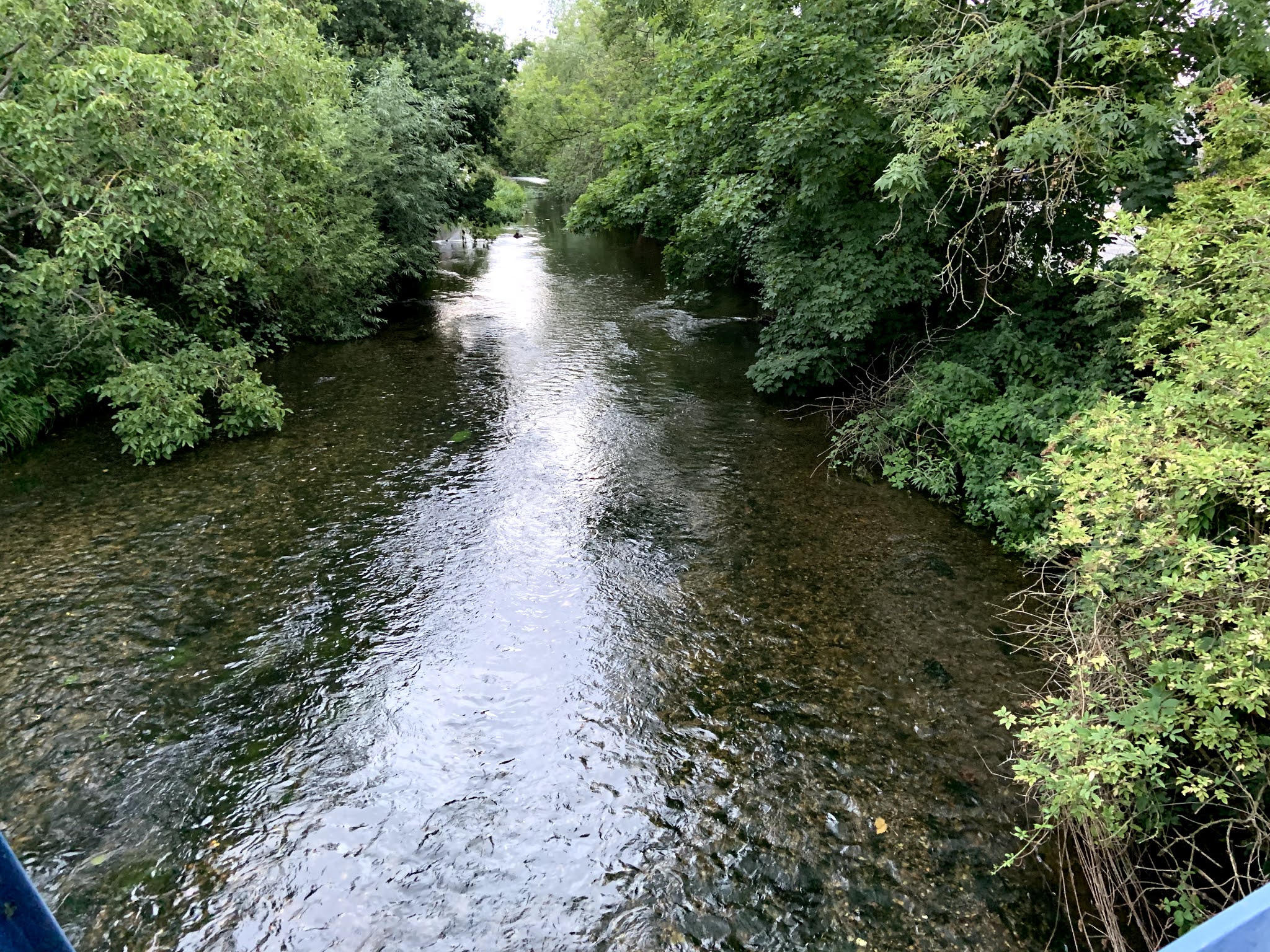
One of my favourite sections came next where the river goes under the railway line from London to Epsom. The footpath follows the stream through a culvert/tunnel under the railway which surmounts an embankment. What made it more enticing to me was the fact the path is on a raised platform over the stream.
Duck!

Out the other side. After the Stygian darkness you emerge into verdant meadows and re-birth. How's that for a bit of arty-fartiness?

It becomes a little harder to determine which is the main stream, there seem to be branches all over the place, possibly fed by different springs. There are also what appear to be ponds, but perhaps the stream is just sluggish. Some lucky people have quaint-looking houses which back onto the water (or maybe not so lucky if it floods). I was tempted to capture the scene but it seemed intrusive so I left it and walked on.

Near the end now

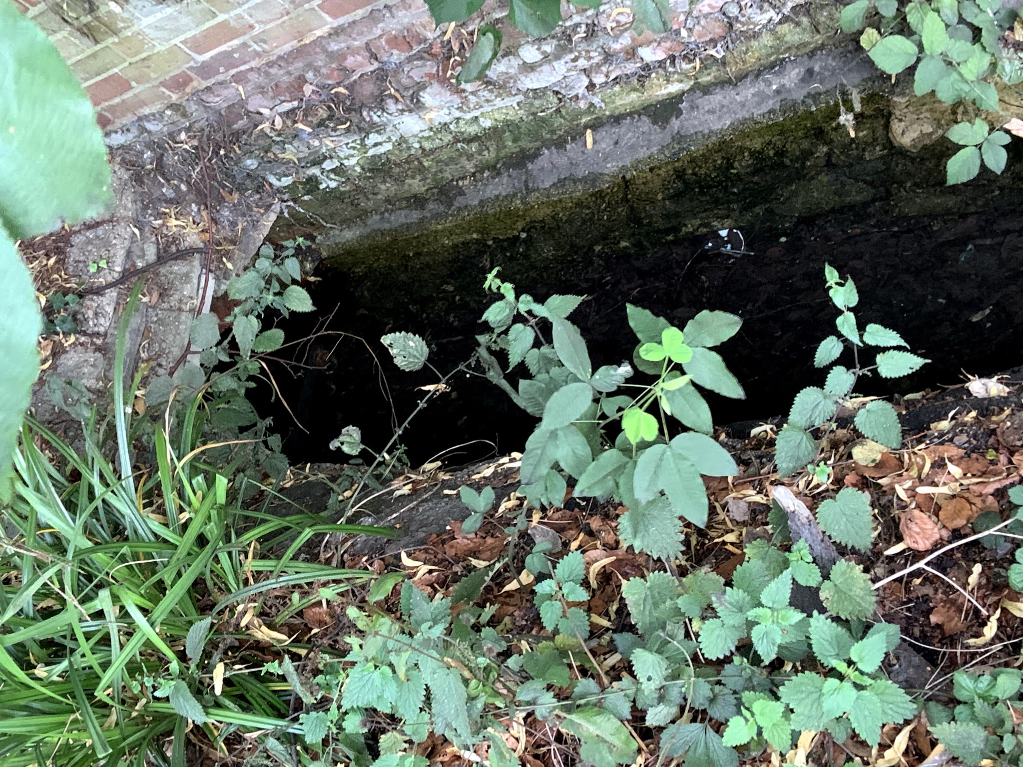
One final bit of parkland led me to what I presumed was the source. There's an ornamental pond with a fountain, and in a walled surround there's a narrow stream which comes out of a culvert.


Ah yes! This must be it.


Having checked that I had 20-odd minutes to wait for a bus I nipped into the Source for what I hoped would be some refreshment. Sadly it's 'restaurantified' and the bar had no real ale so I didn't linger longer than it took to make use of the hand gel.

So I've done it now. From Thames to source. Not exactly Henry Morgan Stanley I admit. It's not the prettiest, most bucolic river that I've ever walked along, but it's here and it does have its diversions. There's certainly a lot of history along the Hogsmill's short 6 mile length. The walk gave me a better feel for the terrain hereabouts too, and enabled me to connect the dots a little better than driving ever would. As a wargamer, there are, naturally, scenarios milling around the back of my mind. Of that, more anon.

Onto the Beverley Brook. I think.

Sunday 26 July 2020

Old Fritz book giveaway


Due to an error on my part, I ordered two copies of Der Alte Fritz in 50 Bildern from an Amazon trader in Germany. I tried cancelling the second order immediately but the company seemed to be operating along Schlieffen lines. Once the order was placed, there was no stopping the trains, even though the train wouldn’t depart for a number of days so to speak. I would have to wait for the goods to be posted, then when they arrived send them back for a refund!

I’m sorry but we appear to have accidentally invaded Belgium.

S** that for a game of soldiers. If I’m going to the post office to post the book it may as well go to someone who’ll appreciate it, ‘free, gratis and for nothing’.

If any of (either of?) the blog’s registered followers would like it, add a comment in the usual way by Saturday 1August 12:00 BST, and I’ll post it to you. In case there’s more than one person who would like the book, include with your message a suggestion for the following conundrum. The suggestions will be used as a tie-breaker. Judging will be completely subjective of course.

Years ago on a work trip to Berlin I turned into Unter den Linden in search of the Berlin Zinnfigurinen shop. Who should I come across walking the other way but His Majesty King Frederick II. No one in the street seemed to take any notice of the man. I have no idea whether this was some sort of actor in a tourist role or advertising stunt, a ghost, or a kind of auto-suggestion arising from my mind associating the location with the King. I searched for some appropriate words to say but nothing came and the moment passed. So what, dear reader, should I have said to the apparition?

I’ll announce the ‘winner’ next weekend.

Sample of one of the pics.

Any similarity to the process for giveaways on Prometheus in Aspic is purely intentional.

This is going to be harder than I thought. I’ve already had some cracking suggestions already from the east of England and western US.

Tuesday 21 July 2020

More rambling - Weelsby and Clee

We’re ‘oop North’ visiting the parental home for what may be the last time, if it is sold in the near future. After fish and chips (which you HAVE to do if in the area) a walk was called for.

Clee with Weelsby was a rural parish that was administratively absorbed by the borough of Grimsby in the late nineteenth century. Clee itself was the mother village of three Anglo-Saxon daughter settlements (or ‘thorpes’). By the time of Clee’s absorption into Grimsby, the thorpes has grown together to become a small town (Cleethorpes) which with investment by a railway company developed into a seaside resort.

Clee, or Old Clee as it’s now known, was of course the site of a battle during the Civil War that never made it into the history books. 😉 Click here for the Battle of Clee Fields


Close by is an open space/parkland called Weelsby Woods. Beyond that lies the open countryside of Lincolnshire. Weelsby Woods was donated by local bigwig Sir Fred Parks. During WWII it was the site of a POW camp for Italians. My father remembers seeing them marching off on work details, happily singing, presumably as they had a stereotype to live up to. He also said that later in the war the camp housed former Soviet soldiers, captured in Wehrmacht uniforms in Normandy, though I haven’t seen this corroborated. Naturally he told me that they sang sad songs when on the way to their work details. After the War these Soviets were shipped back to the Motherland and the People’s retribution.

After the War ended the camp was used by Free Polish forces pending repatriation/resettlement. Many stayed in the UK and some settled in the Grimsby area, some surviving to see a new wave of Polish immigrants in the present century. Their contribution to the War effort and local community was recognised in 2010. Here’s a commemorative board with some pen portraits of some of the officers.


I didn’t notice the statue honouring Wojtek the bear, the mascot of the Carpathian Brigade’s attached artillery unit.

Wojtek was adopted by Polish troops on the way through Iran in 1942. The troops concerned had been released by Uncle Joe to fight with the western Allies. Wojtek emulated the gunners’ supply team and carried ammunition to the battery’s 25-pounders. In action!  He was promoted to corporal for distinguished service at Monte Cassino.


Late edit: I just remembered that as a youth of 16 I got speaking to an old lady in Cleethorpes who claimed to be a Polish princess. She said she was married to a Polish prince from Silesia. Her husband didn’t seem inclined to either confirm or deny that story, but he was Polish. The woman said her husband was in the Polish army when the war broke out in 1939, and because he was Silesian he was drafted into the Wehrmacht as Germany had reclaimed the former Prussian province. According to the old lady’s story, the man joined the German Fallschirmjägers and on being captured by the British then took the opportunity to swap back to the Polish army where he became a member of the Polish parachute brigade and fought at Arnhem. I took it with a pinch of salt but thought that the Silesian part of it was plausible.

PS: apologies for the formatting. I seem to have a glitch with Blogger. - Late Late edit: I managed to resolve this from my laptop.

Sunday 19 July 2020

More watery adventures

The last week's evening walking involved a fair amount of riverside perambulating. Having done the middle section of the Hogsmill (New Malden to Old Malden), I went to see how far I could get from the Thames walking alongside the stream.

So the start was a walk down to Kingston town itself. In fact what I assume to be the original heart of the town where the Hogsmill meets the Thames. Modern tradition has it, and I'm not sure how much of this is supported by sources, 7 Anglo-Saxon kings were crowned here in the 10th century. This included the first king of all England, Athelstan.


Once down on the Thames we turned upstream for a short distance until we cam to the mouth of the Hogsmill. The area around there is almost all turn of the millenium development, including a tidy looking complex of walkways and little islands where the Hogsmill enters the Thames. Not the prettiest of sights but it is designed to encourage wild-life as well as commercial life (there are lots of bars and restaurants in the area).


A short stroll up the Hogsmill brings you to the 12th century Clattern Bridge. It looks old but it doesn't look that old because it's been built up over the centuries. There's fabulous 18th century map of the town on the Wikipedia page which just screams 'wargaming scenarios' to me. 


On the map on the opposite side of the Thames from Kingston you can see the edge of Hampton Court Palace Park on the right. The open land under Hampton (this settlement is known as Hampton Wick now, Hampton proper is a couple of miles away) is Bushy Park, another large Royal Park close to where SHAEF HQ was and the NPL is. There's also an eyot downstream of Kingston Bridge (left on the map) which no longer exists. Top left on the map is a farm (Canbury) which is roughly where the Hawker factory was mentioned in a previous post. I also learnt from the Wiki entry that there was an annual game of football played on Shrove Tuesday between Clattern Bridge and Kingston Bridge which legend has it dated back to the 8th century but was ended in the 19th century by busybodies.

The Clattern Bridge looking downstream towards the Thames.

Back to the walk. Close to the Clattern Bridge is the administrative centre of Kingston where the Guildhall (borough council HQ) and police station are located. But more interestingly the area holds this, which is supposedly the English version of the Stone of Scone. Again I don't know how true this is, but it's a nice thought.


Next time I'll try to remember some wipes

Continuing upstream from the Guildhall there are some nice views, nothing spectacular but nice to see in a built up area. Much of the stretch around here, an area formerly inhabited by flour mills, is occupied by the University of Kingston. On one of the islands there's also a community garden for the local flat dwellers. Whilst most of the river has steep banks (often concrete) there are places where you can walk down to the waters edge, which I pointed out to Daughter III as a nice place to hang out.

One of a number of weirs on this stretch


A peak through the fence at the community garden

As photogenic sights go, that's about it for this stretch of the Hogsmill. A couple of hundred metres later you read Villiers Road which presumably honours the Duke of Buckingham's young brother killed at the Battle of Surbiton in 1648. There are a couple more street names in the locality connected with this, Villiers Avenue, Villiers Close and Buckingham Road. Nothing to the actual victor, Sir Michael Livesey, though. Bloody Royalists. 

You cannot walk along the Hogsmill at this point until you rejoin it at Green Lanes Park, after the local sewerage works - I pointed out to Daughter III that that smell comes from something which is one of the biggest contributions to life expectancy in human history.

Later in the week we intended to walk along the stretch of the Beverley Brook that lies within Richmond Park, but got distracted by a footpath that we didn't know about before. We followed it all the way (about a km) to Putney Heath then swung in through Roehampton, the location of the flats referred to in this post from 3 weeks ago Country or city? Going round the block. As well as the tower blocks, there is a wide variety of low rise blocks, and small house (including a few 1 storey buildings, not too dissimilar from those Post-War prefabs). The only riverine stretch of that walk was crossing the Beverley Brook back in Richmond Park. Daughter III and I cooled our feet off by walking through it barefoot while Äiti used the bridge.

One final stretch of water that I walked (yesterday) was a short section of the Longford River. This is an artificial river built to embellish Bushy Park. It was a Red Letter Day for me. I was walking this route back home from Hampton Pool (open air swimming pool) which reopened on Friday. I'd been waiting for that day for four months, and it didn't disappoint. The weather was perfect, the arrangements for ensuring that swimmers were safe were impeccable. The swim was hard as I haven't kept my arms in condition and tiredness meant that my breathing soon went to pot. But this is one of the things that I like about swimming. It's largely a matter of getting control of your mind and body and forcing yourself to do things properly. You know you are getting it right when it feels like you are swimming downhill. I was a happy boy.


Wednesday 15 July 2020

Banana Republic

We're now the sort of country where scores of people can die in a fire because corners were cut on safety. Reports into alleged foreign (i.e. Russian) intervention in our elections are buried (of course there's nothing to hide). Political advisors to the PM are allowed to flout government set rules restricting movement during a pandemic*, and now the most senior civil servant of the country is forced out (with a nice tasty bung) with his job being split and half of it (as National Security Advisor no less) given to a SPAD (Special Advisor - a political appointee). And public procurement contracts are awarded to political cronies without a hint of due process being applied. Oh and we’re now regarded as a Covid19 high risk country (witness the restrictions placed on British members of F1 teams for the Hungarian Grand Prix).

The travelling political advisor is now being let loose on the Ministry of Defence. Now I'm not a big fan of the MOD, but I think if Cumming-and-Going performs his magic, expect massive disruption with no discernible benefit to the defence of the Realm. Well done Mr Putin! Your plan is coming together nicely.

Now the following is worth a read. I get the ‘emergency argument’, we can skip the EU procurement regs on advertising,  but in an emergency you don’t rely on companies who have no expertise or assets to deliver what you need. Public procurement departments will have a lot of information on qualified firms from their previous pre-qualification exercises/RFIs or whatever is the preferred term. Running tenders is also a relatively quick process in the 21st century so there is absolutely no excuse.


Stands back in expectation of wails that this is all anti-Brexit propaganda.

* I'm still VERY angry about this. Many people have died, not just of Covid-19, without any relatives by their bedside. Many more have not been allowed to hold proper funerals let alone gather afterwards to send the beloved deceased off in the traditional fashion. All this was perfectly tolerable, if disappointing, because we all recognised the need to minimise contact. That's when we thought we were all in it together. 

PS I keep having to add more and more to this. I’ve just read that the Conservative MP who was elected chair of the Intelligence and Security Committee, in opposition to the PM’s preferred candidate, and serial ministerial cock-up artist, Chris Grayling, has lost the party whip**. This is the committee which will decide whether or not the report on alleged Russian interference in elections should be published. Obviously the two things are totally unconnected.

** I.e. kicked out of the party.

Tuesday 14 July 2020

Echoes of past wars - More local walks

This blog is rapidly turning into a local travelogue of the Kingston-upon-Thames area. I promise you that there are military history angles to this though. Some of all this may feed into ideas I have for a mini-ECW campaign.

In my continuing efforts to keep active pending the re-opening of my preferred swimming spot, I've been continuing my daily walks. Sunday and Monday saw two new walks from my own doorstep in different directions to the ones I've been doing. 

Sunday, shortly after lunch*,  Rouva Nundanket and I left the Schloss (or Linna as she insists on calling it)  and met Lincolnshire Tom and his wife in West Wimbledon with a view to having a walk around Wimbledon Common. The walk proper started along the banks of the [corrected text here] Beverley Brook, a tributary of the Thames which runs through one side of Richmond Park and eventually into the Thames near Putney. Sadly we spotted no small creatures collecting rubbish (maybe like doggers they come out after dark) but did come across this splendid war memorial to the north of the common.


Better pictures can be seen here:

Heading slightly further south we then came across another small monument in the form of a short obelisk (do correct me if that's the wrong term). One side was an inscription to the Queens Royal Surrey Regiment (which was latterly merged into the Princess of Wales's Royal Regiment). The reverse was a memorial to the Tangier Regiment which had paraded on nearby Putney Heath. Well spotted Tom! 


I wanted to have a gander at 'Caesar's Camp' at the southern side of the common, and as this was heading back to where we wanted to end the walk it was easy to persuade the others to walk that way. Somehow all way finding methods failed us (or more accurately, we messed up) and were about to give up. and were heading for a way out. This involved climbing a fairly steep slope and then just as we found a path that went through a golf course we came across it. it seems that the golf course is slap bang on the 'camp', which was in fact an Iron Age hill fort. Being under the golf course we couldn't actually see much of it.


This is looking in the opposite direction to the plaque above. The ground drops away steeply forward and to the left here so I assume it’s the ditch of the earthwork. 


This is on a pretty high spot, and you can see why the fort was up there.

Tom was excited to note that you could “see Tolworth Tower from here”. Not that it’s on this picture.

But here, thrill seekers, you can see the famed twin towers of New Malden. Down below is the valley of the Hogsmill. [correction! Below is the valley of the Beverley Brook. What an embarrassing mistake to make.] The river is between this ridge and another lower one before you get to the towers. Roughly 60 degrees right of this view are two higher points, Coombe and Kingston Hills.


Monday we decided to head in a different direction and much to one of our daughter's annoyance, we said were walking to a park where she has taken to hang out this Summer. Nothing special but it borders the Hogsmill River, which is a tributary of the Thames that flows through Kingston. I wanted to see if I could make it into town all the way along the river bank. I referenced the Hogsmill before in my post on the Battle of Surbiton, 1648.  Back then I wondered whether the powder mills shown on the map were around in the Civil War. I discovered this evening that they made powder for the Napoleonic Wars. You can see the Hogsmill just to the east of the area I circled as possibly being the site of the Surbiton battle.

When we got to the park we thought we'd cross to the western side via a footbridge and head over towards Berrylands and Surbiton. Then we spotted the pleasant looking open space heading upstream (later discovered to be 'Elmbridge Meadows'). We followed this for maybe half a mile when the path ended at the busy A3 (3 lanes on each carriageway). We were given directions to an underpass and then eventually found the continuation of the river and more open space on the other side. After about 3/4 of a mile, and a steep incline towards the end) we came to the parish church of St John the Baptist, in Old Malden* close to where the powder mills are shown on the Surbiton battle map. 

Beware of dragoons.


The church itself was worth seeing. It had this lovely Lych Gate:


And this beautiful little war memorial. I've never seen one like this before.


Here is a shot of the church which show at least 3 distinct periods of growth/redevelopment. You can see where it was rebuilt in brick in 1611. The oldest part is Saxon.


All in all a couple of interesting little finds for a geek like me.

At some point I hope to carry on following the Hogsmill up to its source near Nonsuch Park, where a palace was built under orders of Henry VIII. The palace was demolished in the late 17th century, so it would have been around at the time of the Civil War. I don't know how long the walkways continue for, and I expect that the journey will entail a bit of walking along roads. But you never know what's around the corner.


* Until the 1870s this was just 'Malden'. With the coming of the railways, a classic railway suburb (New Malden) sprang up a couple of miles to the north. New Malden became the main settlement in the area and someone thought it necessary to add the qualifier 'Old' to 'Malden'. Maybe estate agents were marketing it as quaint village even then.

Late edit: Because of my initial misnaming of the Beverley Brook as the Hogsmill, there's scope for confusion. I've therefore added the map below which shows the area in the early 19th century. I used the same map in my post on the Battle of Surbiton. The blue annotations show the area of my Sunday walk, and red shows the area of my Monday walk.