This post is later than planned. I fell asleep on the sofa on Sunday evening!
On Sunday I attended the Battlefields Trust walks at Brentford and Turnham Green (a couple of miles from each other in west London. Here's a map for context, Brentford in the far west, Turnham Green is at Chiswick just to the east of Brentford. The cities of Westminster and London are the potential prizes for the Royalists in the east.
The guided walks were excellently led by Charlie Cordell and Simon Marsh of the Battlefields Trust. Charlie led the Brentford walk in the morning and Simon, the Turnham Green walk in the afternoon. Each lasted 1.5-2 hours. We were given a very good political and strategic background to the events of 12-14 November 1642. What came across well was that political considerations trumped strategic and tactical ones. This helped to explain some of the decisions taken by the rival generals. We were also given an overview of what the town of Brentford was like in the early 17th century and why it was significant. This was equally valuable context.
The Brentford walk started with an explanation of events close to Syon Park (extreme SW of the above map) where the Royalist advance guard came into contact with a Parliamentarian picket (a company from Holles' foot regiment). We then proceeded up what was then the main road to London from the West Country, stopping at various junctures to have particular parts of the engagement explained, or key features to be pointed out. Obviously the area has changed enormously in the past 380 years, but the substrate is still noticeable rather like the outline of early medieval buildings in aerial photographs of fields. I won't give a blow-by-blow account of the action. You can find this elsewhere, for example here, on Charlie's website:
https://charlescordell.com/brentford-turnham-green-1642/
I've not seen this before, so it will go into my bookmarks folder. There's also this leaflet from the Battlefields trust, which includes a near contemporary map of Brentford, and a map from a survey in the 1740s showing the area of the Turnham Green confrontation.
https://www.battlefieldstrust.com/brentfordandturnhamgreen/images/visiting/Battlefield-Trail-Leaflet.pdf
Whilst it is impossible to see the lie of the land as it was in 1642, it is still possible to get some meaningful insight from these walks. Having walked the Brentford battlefield before, without guides, I have to say you get an awful lot more having the key points and the background explained on the spot as it were.
I would highly recommend it.
I'll leave you with a link to the Battlefields trust Events page, and some snaps taken yesterday.
Note that the Trust runs some on-line events, which might be of interest to folk overseas.
 |
| View roughly NE from Brentford bridge. River Brent is the right hand fork. left fork is the Grand Union Canal. |
 |
| Underneath the rail bridge by Turnham Green Tube station. The District Line off the 'Underground' is overground in this area. The maps show the development of Chiswick from the 1590s. |
 |
| Whilst showing the new Chiswick House a century later (dark area in the centre), this gives a good idea of the area of the Turnham Green battle. The Royalist right flank was at Chiswick House (then a Jacobean structure). Below that were the meadows - very wet ground, especially in Autumn 1642. The armies faced each other across the open ground to the north. Market gardens and orchards to the west. |
 |
| View from the left (northern) flank of the Royalists positions towards where the Roundheads were. The legend that Prince Rupert tied his horse to this bench is clearly untrue. He was on the right wing! There is evidence of Parliamentarian cavalry at the other end and just off to the right. |
 |
| From the same position but looking along the Royalist position. |
 |
| A Roundhead brigade found itself somewhere in that direction, outflanking the Royalist position, but they were called back by a cautious Earl of Essex. To be fair to Old Robin the days were short and dark, and all he had to do was avoid defeat. |
 |
| There I told you there was evidence of the Roundhead cavalry! |


Looks great, I will keep an eye on their listings in case of a repeat! It poured with rain all day yesterday where I was, looks like you were more fortunate - or you just put up with getting wet?
ReplyDeleteWe were really lucky in the morning. It rained until I got off the bus in Brentford. It started raining again shortly before we met for the Turnham Green leg, but stopped not long after.
DeleteChris
Both tours sound really good and maybe I might get lucky and have some in and around Bristol. The info boards are good and I love the near contemporary maps, especially those showing the market gardens etc, which is very useful for us gamers when setting up the game.
ReplyDeleteI reckon the cafe was actually set up by Del & Rodney after the battle as an independent concern serving the trade along the old London Road;).
This comment has been removed by the author.
DeleteThat was my thinking Steve about the market gardens. Brentford was essentially an infantry action given the constricted nature of the ground. Two regiments of Parlie foot (Denzill Holles and Lord Brookes) and possibly a brigade or more of Royalist foot. Some Royalist cavalry were involved but the details are a bit hazy. There were a couple of fords (as well as the bridge) which the cavaliers may have used to cross the Brent. The Parliamentarian unit present before the action soon disappeared from the accounts, so maybe they hot-footed it when the noise started. They had been on the left wing that routed at Edgehill. Later John Hamden's regiment of foot arrived to cover the retreat. So all in all a nice manageable action on the table.
DeleteVery enjoyable travelogue, Chris! Adding in the placards and maps helped me to get my bearings on the walk. Thank you!
ReplyDeleteYou're welcome Jonathan. I'd recommend looking at the leaflet, though note that the Brentford maps have West at the top. The road through the town is the Great West Road which appears on the Turnham Green map. (bottom left).
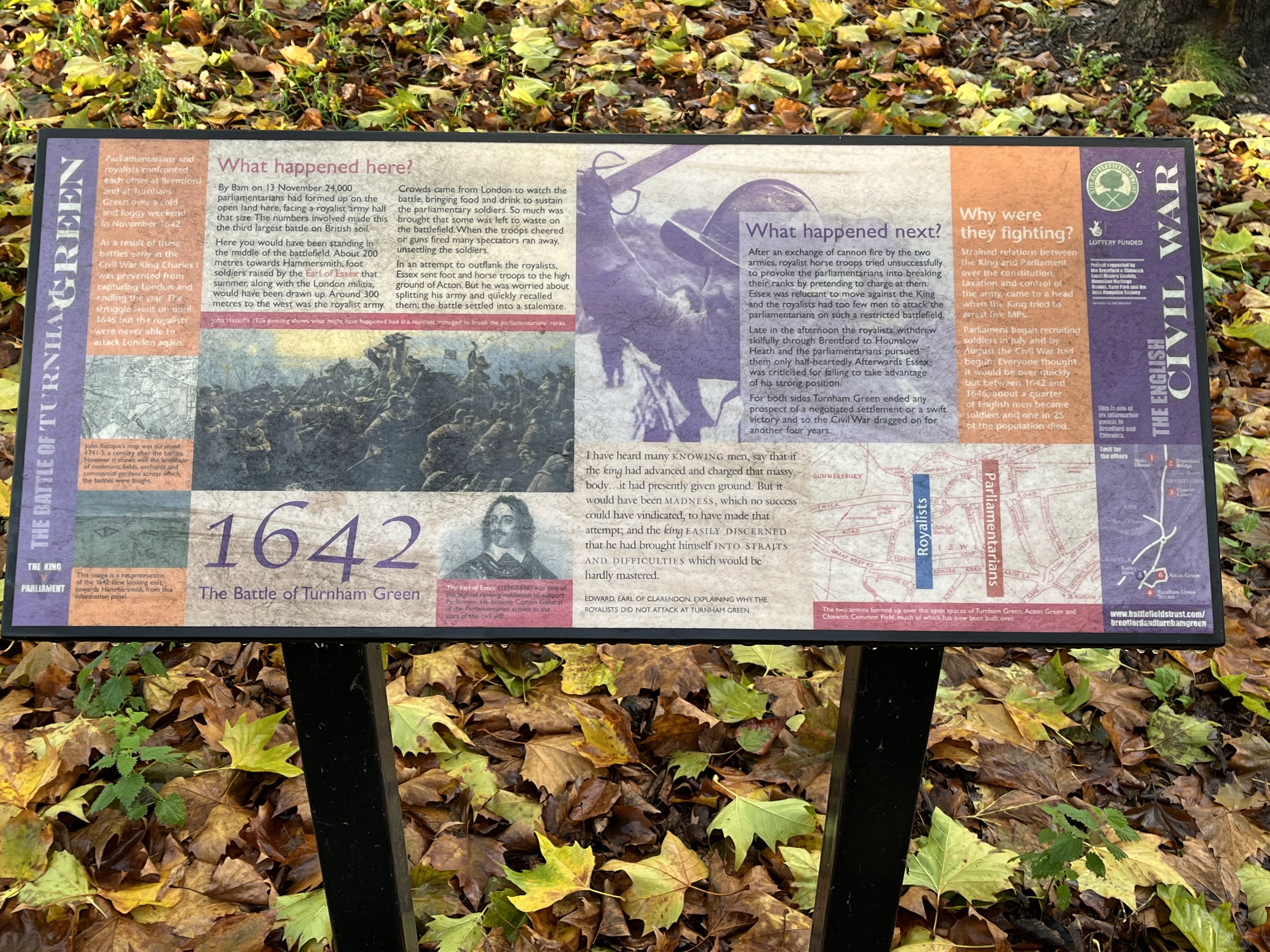
DeleteSteve beat me to the Only Fools and Horses reference - bugger! The information boards look good, as Jon mentioned. Nice to see this sort of thing being put up and maintained nowadays. I can't quite read the "Why were they fighting" portion in the first image - would be interested to know what the author thought!
ReplyDeleteHi Keith. The “why they were fighting panel” talks about strained relations between King and Parliament over control of taxation and the constitution. Then goes on to say both sides raised armies. Eventually 1/4 of the male population served as soldiers at some point and 1 in 25 of the population died.
DeleteChris
Really interesting walk and thanks for sharing the info on the battlefield trust walks 👍
ReplyDeleteYou’re welcome Matt. Glad it’s of interest.
DeleteChris
Very enjoyable post, with lots of useful information; thanks. The Battlefields Trust do very good work. Only a relatively few years ago attempts to build on or otherwise wreck important sites met next to no opposition. They've certainly changed that! And no, Rupert would certainly not have tied his horse to a bench; he'd either have tied it to one of his many flunkeys or got one of them to tie it to the bench (on the right wing, obviously). ;-)
ReplyDeleteCheers,
David.
A nice tour indeed!
ReplyDeleteIt was a very pleasant and interesting way to spend the day.
DeleteChris