Friday, 28 February 2025
Shameful
Saturday, 22 February 2025
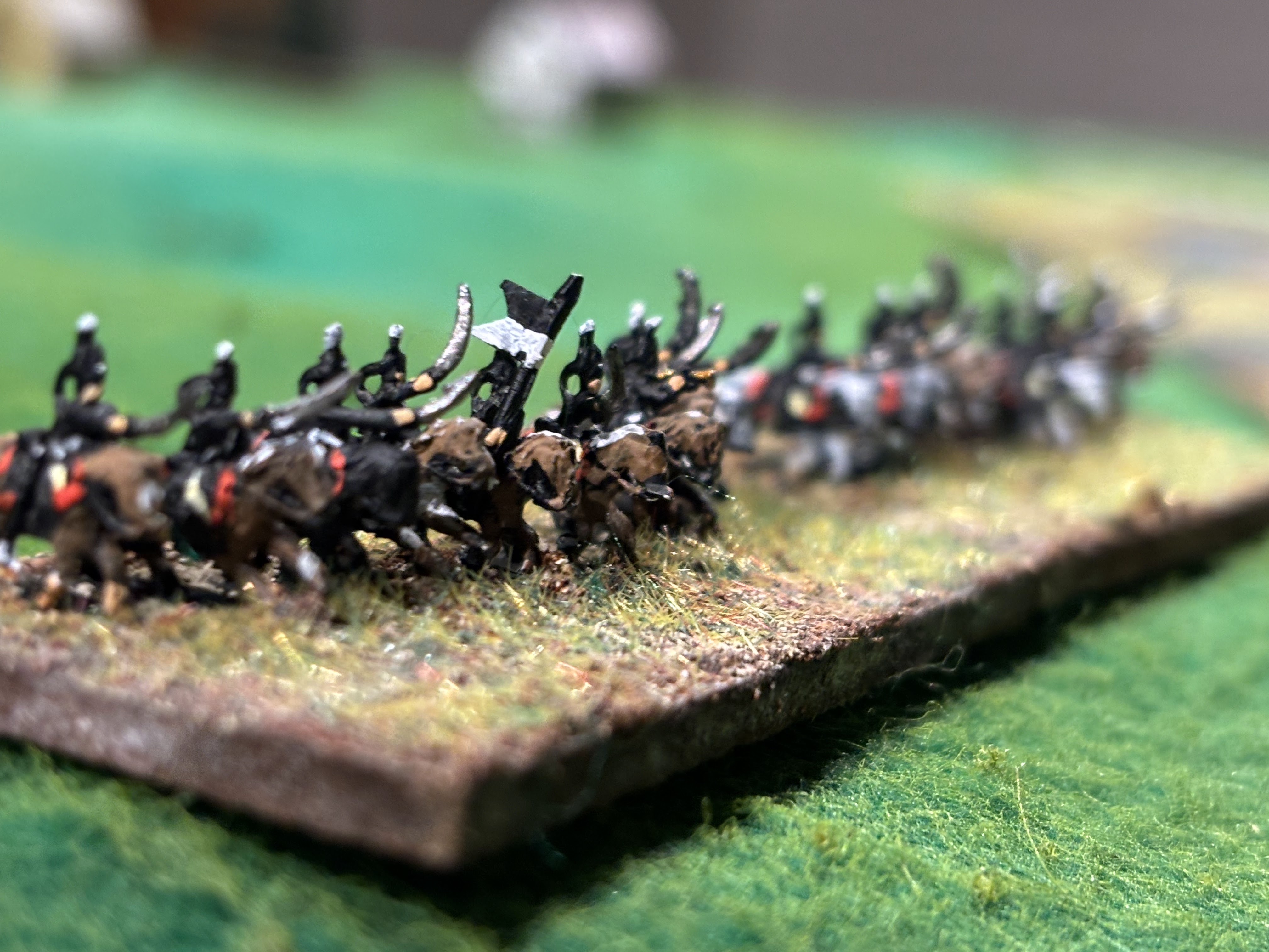
The Battle of Jaromiersch - a 1757 Campaign game
As trailed in the previous post, the first turn moves led to a battle. Dave C, in the guise of Prince Henry of Prussia, had marched a small force down from the Silesian border to the town of Jaromiersch (modern day Jaroměř in Czechia). Detecting a much weaker force, Serbelloni seized his opportunity.
The name Jaromirz, as shown on the German Great General Staff ('3GS') map which I used as the campaign map, rang a bell. I consulted Duffy, and in Frederick the Great: A Military Life, there was a map from the War of the Bavarian Succession of the rival positions at Jaromiersch. A bit of cross-referencing showed that this was indeed the same place and the map in Duffy was used as a basis for the table top game. I drew on roads (interpolated from another 3GS map of the region). Dave was invited to place Henry's force anywhere on the map and to give his general orders for the battle.
 |
| Henry placed a brigade of infantry at Jaromiersch, one at Schlorten and a unit of Freikorps at Schurz to contest the crossings as long as possible, with a brigade each of hussars and dragoons in between to cover the expected retreat. Austrians advanced from the left. |
 |
| Looking south towards Jaromiersch. Schlorten in the foreground on the right bank. This is a 1m x 1.2m table by the way. |
Serbelloni concentrated the larger part of his army on Jaromiersch, with a smaller grouping of infantry of infantry and dragoons at Schlorten. A unit of hussars was sent to scout and, if practicable, force the crossing at Schurz. A powerful artillery battery was formed across from Jaromiersch to soften up the Prussian defenders, who had no heavy guns of their own. After a protracted bombardment the Prussians retired to the rear of the town. As a long march column of Austrian infantry approached the bridge, the Prussian dragoons advanced towards the town to keep the Austrians pinned or to catch them in column. The dragoons themselves began to suffer from the artillery and retreated out of range.
 |
| Austrian guns moved up to the river, and are about to deploy to bombard the Prussian cavalry |
Meanwhile at Schlorten, two brigades of infantry, backed up by dragoons, assaulted the village occupied by Prussian fusiliers. There ensued a lengthy musketry dual which was indecisive for a long time. Up at Schorz all was quiet with the respective light troops keeping a watchful truce. Live and let live eh?
 |
| Austrians march up to assault Schlorten |
Back in the south, as the Austrian infantry crossed the bridge and began to form into line at right angles to the road, the Prussians emerged from the buildings and began to pour volleys into the Austrians. The Austrians took some losses, but so did the Prussians. Enough to make the brigade break. [i.e. they suffered a third hit].
 |
| Musketry battle by the Elbe |
At Schlorten, both sides suffered losses, but the Prussians came off worse. With Jaromiersch lost, the Prussians' retreat could be cut off, so they withdrew to the opposite bank of the Elbe in good order, covered by the hussars.
 |
| Angry looking Death's Head Hussars |
 |
| Grrr! |
There was no vigorous pursuit by Serbelloni. He was satisfied throwing the Prussians back over the Elbe, and he was conscious at having left Königgrätz vulnerable.
A brief game (c.1/2 hour) with the Prussians suffering twice as many hits as the Austrians. But in the Post Battle phase, they recovered a base (effectively wiping off 3 hits, thus levelling the score). This was helped by the lack of a pursuit. The withdrawal by the Prussians was optional and not enforced because of a failed morale test. Therefore there would be no pursuit.
Sunday, 16 February 2025
The Campaign Commences
April 1757. Early spring in Central Europe. The usual reports came to Brown in Prague of the King of Prussia wasting his efforts in shuffling soldiers around Saxony and Silesia. Earlier he had launched a raid toward Franconia, but other than that no significant movement was noted or expected. It's far too early to find enough forage for a large army. The Empress's rich province of Bohemia was safe for now. Once the Hofkriegsrat in Vienna made its mind up, Browne would lead an army to liberate Saxony.
 |
| The quiet borderlands between Saxony and Bohemia |
 |
| Hussars and Croats patrol the borders |
 |
| The grass is still too brown to support many horses |
 |
| Frederick has been ensconced in one of the Polish King's hunting lodges (the Polish King also being Elector of Saxony, exiled because of Frederick's invasion the previous year) |
 |
| Carp ponds close to the hunting lodge. |
Then the reports began to trickle in. Of Prussian incursions along a broad span of the frontier. From Saxony into north western Bohemia. And from Silesia in the north east. But this could not be an invasion surely, with such a dispersal of forces. If it was, the King deserved to be beaten.
In a matter of days Frederick's forces had penetrated the thin cordon of Austrian light troops. At Teplitz and Komatau, a few marches from Prague). And more worrying, at Podersham to the west of Prague. In the north east Schwerin crossed the Silesian border, marching through Trautenau on his way to Neu-Paka, driving a wedge between Königsegg guarding the Lusatian border, and Serbelloni at Königgrätz. Meanwhile, Prince Henry with a small force, fixed Serbelloni's attention in the Jaromirz direction.
 |
| Prussian positions after their first move. Austrian starting points are shown as the red shaded areas. The map is from the German General Staff history. Tweaked to add a few towns and blot out others. Movement is point-to-point as in the original Age of Reason Bohemian Blitzkrieg game, but to offer more variation in routes, I've gone for a slightly bigger map with more towns and roads. |
Intelligence was not so easy to come by on the Prussian side either. The Austrians concentrations were where expected (Wintefeldt's spy-ring had been active over the winter). But powerful screens of cavalry had prevented close inspection of the Austrian forces. In possession of many hussars and croats, Serbelloni had kept a watchful eye on the border in the Nachod direction (less so towards Trautenau) and discovered the size and composition of Henry's weak force. He would outnumber him 2 or 3 to 1. His Milanese pride could not resist such a tempting target (he rolled a 5 when he needed a 5 or 6 on the Initiative Test). What will Henry’s reaction be?
More on the game: As mentioned before, this is based on the Age of Reason campaign game 'Bohemian Blitzkrieg' but with a few key differences. It is being played 'one-sided', i.e. a team of players are all on the Prussian side, with the Austrians controlled but the Gamesmaster (i.e. me). The map is different, as described above. Players are given free rein to allocate their forces and commanders so don't necessarily follow either historical deployments or those in Bohemian Blitzkrieg. The Prussian units available are based on the orders of battle given in Kronoskaf here. Austrian commands and units are based on the historic positions and organisation as far as I have been able to ascertain, with a little bit of tweaking to add to the 'fog'. I've developed scouting and screening rules further, to allow 'operational scouting' as well as the grand tactical scouting in Bohemian Blitzkrieg.
The players are: Jonathan Freitag from Palouse Wargaming Journal, David from the Ragged Soldier and Dave C from St Cyr on Wheels. Jon is taking on the role of Frederick (Old Freitz - sorry couldn't resist), Dave C is Schwerin and Henry, whilst Dave B fills the boots of Keith, Bevern and Winterfeldt.
Saturday, 15 February 2025
Ken Burns meets Yankee Doodle Dandy
https://deadline.com/2025/02/ken-burns-the-american-revolution-london-tv-screenings-1236281377/
This is one to look forward to going by his treatment of the US Civil War and the Vietnam War.
Thursday, 6 February 2025
E.Molesey to Walton-on-Thames
Sunday was bright and sunny*, if a tad cold, and as I'd had a football day on Saturday, I readily agreed to a walk with the Margravina. Let's go by the river for a change, I said, park in Bushy Park then walk from Hampton Court to Kingston then back down to the car through Bushy Park (a nice D-shaped route). Parking proved as difficult as we expected (the World and his wife, plus kids and Labradoodle were out). So an off the cuff Plan B was to cross the river by Hampton Court Bridge and try to park along Riverbank or as close to it as we could. We ended up having to go so far down that we changed walking route and headed upstream rather than down.
* isn't that tautological?
 |
| There and Back Again: from the red dot towards top right, to the blue dot, bottom left and back. Around 6 miles by the Thames river path. Hampton Court Palace top right. |
This turned out to be one of those serendipitous eventualities, for we had a wonderful walk. The number of walkers soon reduced as we got further from the starting point (until we got to the other end). It's not far and it's flat! There were many stops for photo opportunities on the way out. We earned our roast dinner at the pub by the blue dot, and hot-footed it back to the car the way we had come. Only with far fewer stops.
[Incidentally, Blogger is playing up again. At least when trying to post pictures. Messing up the order if you post more than a few at a time, then making them disappear when you try to type captions.]
 |
| Some impressive house boats along this stretch (by Ash and Taggs Islands) |
 |
| Surely one of the oldest cricket clubs. |


 |
| View of Hampton riverside. This is in Greater London! Incidentally, the top side of the river on the map is within Greater London, the bottom side of the map is in Surrey. The London side presented the more picturesque buildings by and large. The Surrey side is hardly any less developed, but "oh no, we couldn't possibly be included in London, we're Sarrey don't you know". Such were the vagaries of local government reorganisation in the early 60s. |
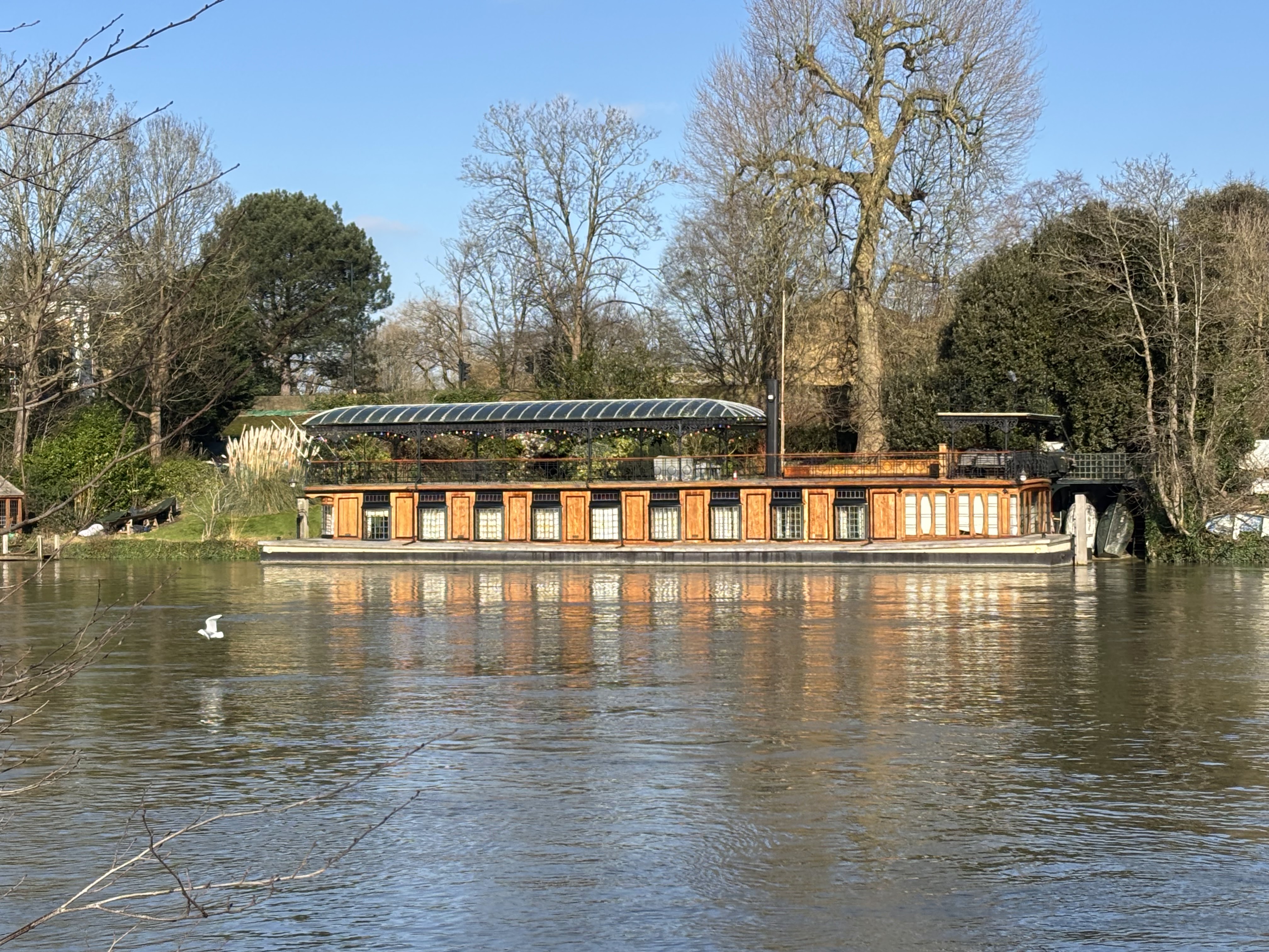 | ||||
The Astoria Houseboat, built for music hall impresario Fred Karno in 1913. Fred entertained Charlie Chaplin here. Moored on the Middlesex (left) bank, near Hampton. Karno had a hotel built on Taggs Island, 'the Karsino', which later became the 'Thames Riviera'. The 111 bus from Kingston to Heathrow has recorded announcements for the upcoming stops, one of which is 'Thames Riviera'.
|

 |
| Garrick's temple (now the wrong side of the road from the villa |

 |
| St Mary's Church, Hampton |
 |
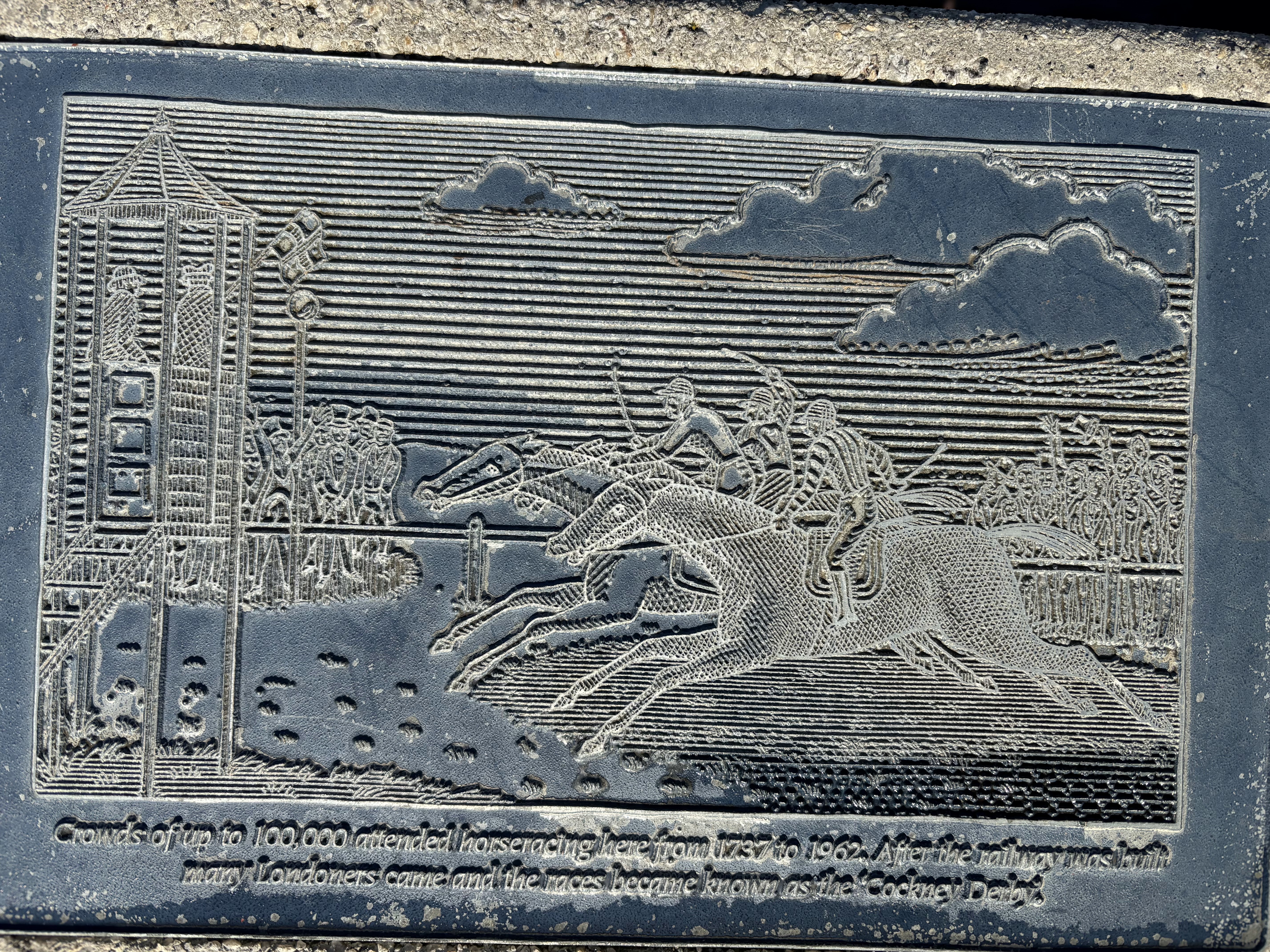
| This and the next few pics are plaques on concrete plinths that form part of a monument to the history of Hurst Park, Molesey, Surrey. Many concern sporting events in the 18th and 19th centuries which attracted crowds up to 200,000! |


 |
| If you stand on the circle with the appropriate month name your shadow tells the time. Almost right. |
 |
| Almost snapped a kingfisher. Dithered too long over getting the right pic: don't let the perfect be the enemy of the good! I had never seen one so close before. Weird and stunning looking creature. |
 |
| This brick wall, backed and topped with an earth bank got me thinking of 'Vauban' fortifications. It was just an old reservoir |
 |
| What's this? |
 |
| Real defensive works (tank traps)? |
 | ||||||
The Margravina, a pretty small human, showing the scale of the thing.
|


Civil War Earthwork
At the weekend Lincolnshire Tom forwarded some pictures from one of his FaceBook groups asking if I'd ever heard of a particular earthwork near Laceby in Lincs. The answer was that this was a complete surprise. Especially as I'd passed close by several times on the A18 on my bike as a teenager, and across the fields when out walking a few years before that. My big question is why there; why is there an isolated fort in that specific location. Puzzling. Answers on a postcard (or blog comment) please.


 |
| Would the roughly rectangular features inside be signs of an old building? A Manor House perhaps. The whole fort measures c200 x 100 yards. |

For a little more context here is a map of the wider area. The built-up place to the top right is the western edge of Grimsby, which would have been a small town of 1-2000 people at the time. The only other relic of the Civil War that I know of (though I don't know for certain that it is) is a ditch and bank around an old farm building in Old Clee, Grimsby, off map to the top right.
 |
| The earthwork is circled in the bottom left. It looks too far from the junction of the roads, and from memory it hasn't a clear line of site owing to the lie of the land. |
Barton Street (the A18 in this stretch) roughly follows the edge of the dip side of the escarpment formed by the Lincolnshire Wolds. Along this line are several springs which are the sources of several streams, or becks, one of which becomes the River Freshney which flowed into what was then the harbour at Grimsby.
If I'd known about this 5 1/2 years ago I'd have woven it into my narrative Lincolnshire campaign.